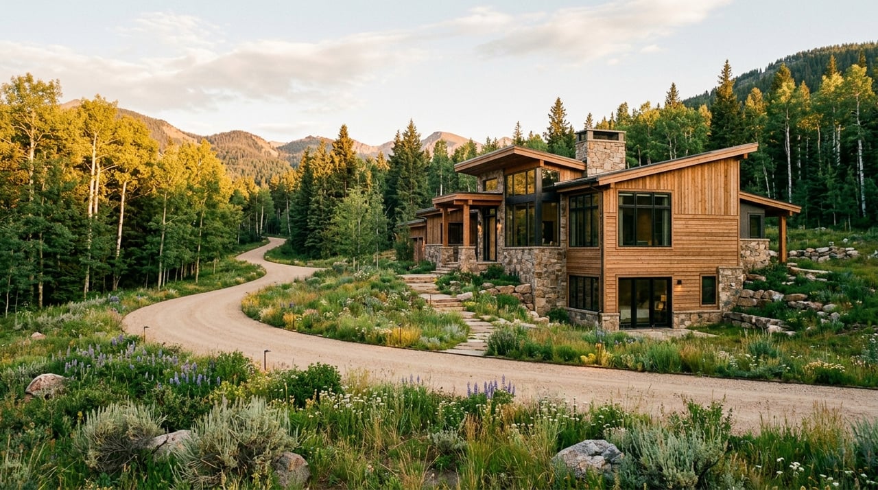
You can fall in love with a Wilson view in a single drive, but buying land here takes more than a quick glance at a map. Between wildlife corridors, scenic protections, and patchwork utilities, two similar-looking parcels can have very different build paths. If you want a smooth custom-home experience, you need to understand the rules that shape where and how you can build. This guide breaks down the key checks, common pitfalls, and smart next steps so you can move forward with confidence. Let’s dive in.
Why Wilson land is unique
Wilson sits in unincorporated Teton County, so development follows the county’s Land Development Regulations, or LDRs. These rules are detailed and site specific. They are your playbook for siting, density, grading, and design. You can review the official standards in the county’s Land Development Regulations.
Two county overlays affect many Wilson parcels. The Natural Resources Overlay protects riparian areas, wetlands, floodplains, and key wildlife habitat. The Scenic Resources Overlay protects major approach corridors and skyline views, often requiring a Visual Resource Analysis. Both overlays can shift your building envelope, screening, and mitigation. Use the county’s interactive map to check these layers early on the Teton County GIS.
Bottom line: buildability in Wilson often comes down to slope and soils, overlay status, water and sewer access, and road conditions. A parcel that looks ideal can still have constraints you only see in the fine print.
Key site factors to review
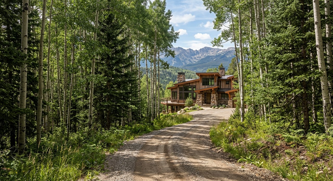
Slope and soils
On steeper lots, the LDRs limit density and control grading and cut-and-fill. Expect more engineering and longer driveways on foothill sites. Flat meadow parcels are usually more straightforward. Before you write an offer on a lot with noticeable grade, plan for a topographic survey and early geotechnical testing. The LDRs outline grading controls, so you will want a geotech to guide foundation type and likely earthwork.
Floodplain and wetlands
Floodplains, wetlands, and waterbodies fall under Natural Resources protections and can carry setbacks or development limits. Always cross-check the parcel against the county’s FEMA Flood Insurance Rate Maps. If you see overlap, consider ordering a formal flood determination and engage the county’s Floodplain Administrator early.
Wildlife and easements
Wilson’s Natural Resources Overlay protects key habitat and migration routes for elk, deer, and moose. That can lead to setbacks, buffers, and native-plant landscaping. Many properties also sit near or within conservation easements. These recorded documents can limit house size, fencing, or siting. If a parcel touches an easement, read the recorded language and, if applicable, speak with the holder, such as the Jackson Hole Land Trust. See recent stewardship context from the Jackson Hole Land Trust.
Groundwater and wells
Some Wilson-area parcels rely on private wells. Groundwater in the valley is often available along alluvial areas, but yields vary site by site. In Wyoming you must secure a permit from the State Engineer’s Office before drilling. Confirm timelines with a licensed driller and review guidance from the State Engineer’s Office. Regionally, domestic wells are often quoted in the low five figures, but you should verify costs with local pros. For an overview of homeowner well considerations, see this Wyoming well guide.
Utilities and access
Water and sewer districts
Wilson is served by a mix of water and sewer districts. Whether your lot sits inside a district affects whether you can connect or must go private. Confirm boundaries, tap capacity, and connection fees directly with the district and the county. The county maintains listings and budgets for special districts, including Wilson-area providers, on the Special Districts page.
Local funding and planning efforts continue to improve water quality and system capacity. For context on recent county actions, review coverage of SPET-supported water projects from Buckrail. Since service can evolve over months and years, verify current plans before you assume a future hookup.
Septic systems
If a parcel lies outside a sewer district, you will likely need an on-site wastewater system. Soils, setbacks to riparian features, and seasonality control feasibility. Expect to provide soils and percolation data to the county. Plan for this work early so you understand your path to approval.
Power and broadband
Confirm whether electric is overhead or underground, where the transformer must sit, and whether a long private run is required. These details can add cost. For broadband, providers have active projects in the area, but availability is site specific. Utility corridors also appear in county GIS layers and can influence siting, so include them in your early map review on the Teton County GIS.
Roads and winter access
Check whether your access road is county maintained or private. County roads are typically plowed. Private roads are the homeowner’s responsibility for maintenance and snow removal. Driveway standards and approach requirements apply for connections to county or state roads under the LDRs. Also confirm emergency access standards with Fire/EMS during early review.
Overlays and design controls
Natural Resources Overlay
If your parcel lies in the NRO, plan for environmental analysis, setbacks, and mitigation. Riparian features can reduce your usable building area, and native-plant landscaping may be required. All specifics are in the county LDRs.
Scenic Resources Overlay and VRA
Parcels visible from key approach corridors, including Highway 22, are subject to Scenic Resources standards. The county often requires a Visual Resource Analysis for homes in mapped foreground or skyline areas. Skyline penetration is generally prohibited unless you demonstrate strict siting and mitigation. Expect the rules to shape height, color, materials, screening, and clustering. See the scenic standards in the LDRs.
Scale and building envelope
The LDRs include a maximum scale of development concept with floor-area and impervious-surface limits tied to lot size, slope, and overlay status. These calculations define how large you can build and how much of the site must remain open. Your architect and planner should review the exact subsections that apply to your parcel.
Conservation easements
If a recorded conservation easement affects a parcel, the easement text controls. Restrictions can include house size, location, fencing, and landscaping. Some easements allow limited development in exchange for other protections. Always review the recorded document and speak with the easement holder when needed. The Jackson Hole Land Trust is a frequent holder in the area.
Due diligence checklist
Use this quick list to reduce risk and speed up planning:
- Pull county GIS layers for zoning, overlays, flood panels, slope, utility districts, and any mapped corridors. Start with the Teton County GIS.
- Request utility availability letters from the applicable water and sewer district, or confirm existing connections. If outside a district, get a preliminary septic and well opinion. Reference the county’s Special Districts listings.
- Order a current title report showing easements, deed restrictions, and private road agreements. Verify maintenance duties for any private road access.
- Commission a boundary and topographic survey and engage a local geotechnical engineer for preliminary soils and foundation guidance.
- If floodplain or wetland layers touch the parcel, hire a hydrologist or wetland consultant for delineation and to scope permits. Use the county’s FEMA FIRM resource to confirm mapping.
- Confirm fire access width, turnarounds, and any water-for-fire standards with Jackson/Teton Fire/EMS.
- Schedule a pre-application meeting with a County Planner to identify required studies, likely discretionary reviews, and any recent LDR amendments. The LDRs outline triggers for Environmental Analysis and VRA.
- Budget for long private utility runs, private road work, grading and retaining on steeper sites, septic or well installation, and scenic or wildlife mitigation. For well permitting and timing, consult the State Engineer’s Office.
- For luxury custom builds, coordinate early among architect, landscape architect, civil engineer, and your county planner so NRO and SRO mitigation gets solved through integrated design rather than last-minute fixes.
Budget, timeline, surprises
In Wilson, permitting often includes multiple steps: pre-application, submittals, reviews, mitigation, and building permits. Build costs vary by design and site, but plan for additional line items on remote or steep parcels. Common surprises include long private utility runs, private road upgrades, required screening in scenic areas, and engineered retaining on slopes.
If you plan to drill a domestic well, regional budgets are often quoted in the low five figures, though yields and timelines are site specific. Confirm permit timing with the State Engineer’s Office and get firm bids from local drillers. For general owner guidance, the Wyoming well guide is a helpful overview.
Your next move
If you are considering a Wilson parcel, take a few early steps that save months later. Verify overlays and flood status, line up a survey and geotech, speak with the water and sewer district about capacity, and meet with a County Planner to confirm required studies. With the right team and clear due diligence, you can protect views, meet the LDRs, and design a home that fits the land.
If you would like an experienced guide to quarterback this process, connect with Jake Kilgrow for discreet buyer representation, due diligence coordination, and introductions to the right local design and engineering partners.
FAQs
What makes buying land in Wilson different?
- Wilson parcels are shaped by county LDRs plus Natural and Scenic overlays that affect siting, size, screening, and mitigation. Start with the Teton County GIS and the county LDRs.
How do I check flood risk on a Wilson lot?
- Compare the parcel to the county’s FEMA Flood Insurance Rate Maps. If there is overlap, consider a formal determination and speak with the Floodplain Administrator.
Can I connect to sewer and water in Wilson?
- It depends on district boundaries and capacity. Confirm service and fees with the applicable provider and review the county’s Special Districts page for current listings.
What is a Visual Resource Analysis in Wilson?
- In Scenic Resources areas, a Visual Resource Analysis studies how your project appears from key corridors. It guides siting, height, materials, and screening under the LDRs.
Do conservation easements limit how I build?
- Yes. The recorded easement language controls house size, location, fencing, and landscaping. Review the document and consult the holder, such as the Jackson Hole Land Trust.